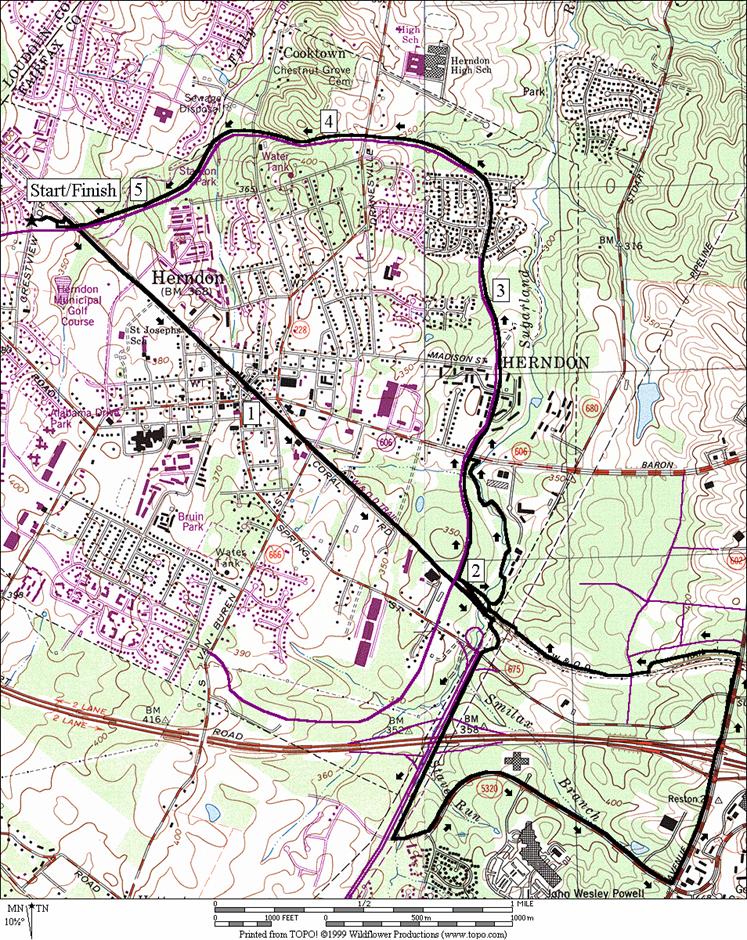
Trailside Park, Herndon
Herndon is not the little rail stop it used to be. Like many of the smaller towns around Washington,
D.C. Herndon has grown and changed. It even installed it=s
own little beltway, the Herndon Parkway,
which makes a complete loop inside the designated town limits. Herndon contrasts with nearby Reston
primarily by being older and more conventional.
It has small downtown area that evolved over time near Herndon station
on the Washington and Old Dominion Railroad, now a paved trail; the Washington
and Old Dominion Trail (W&OD). The
station still stands and is 20.0 miles from Shirlington/24.7 miles from
Purcellville. Several small parks dot
Herndon=s town
limits. Trailside
Park is located next to the
W&OD and is also just off the Herndon Parkway. Cedar trees keep the park cool in
summertime.
Getting There
From the Capital Beltway, I-495
Take Exit 12, for the Washington Dulles Access and Toll
Road, Rte. 267, west. When getting on to the expressway, stay to
the outer (right) lanes. The inner
(left) lanes are only for access to Washington
Dulles International
Airport. Exit after 10.7 miles at Exit 10. Turn right onto Eldon St.
going into Herndon (Centerville Rd,
Rte. 657 is to left at this intersection).
After just under 1 mile, turn left on Sterling
Blvd. Less
than half a mile later, turn right on Crestview Dr. Cross the Herndon
Pkwy., and turn right into Trailside
Park. The trail head is straight ahead from the
lot.
Area Routes
Herndon Parkway (5.4, 9.15 or
5.1 miles, IV, VIII, or IV)
Heading out east on the W&OD Trail, cross over the Herndon
Pkwy, pass the golf course and make your way into
the Herndon downtown area. Pass Herndon
Station, and take your time crossing Eldon St. After a little downhill and crossing some
smaller roads, you=ll cross
over the Herndon Parkway
again. The basic route turns left from
here on a bluestone trail in the woods along Sugarland Run. For an extension, go to Reston,
turning right on the Fairfax County Parkway Trail, following Sunrise
Valley Drive through office parks to Reston
Ave., then take the W&OD Trail back. The extension goes along some busy roads at
some points (see Smilax Branch in the Reston section of
the guide for a description). If it=s wet, a way to avoid the trail along
Sugarland Run is to just go up the Herndon Parkway=s sidewalk. From the trail along Sugarland Run you can
see the old stone arch bridge that was used by the W&OD railroad to get
over the creek. The trail ends at Eldon
St. Cross it again, now on the sidewalk of the Herndon
Pkwy.
Restrooms and water are available at Runnymede
Park. Note that there are some unpaved trails in
Runnymede Park but they don=t
easily loop back well (Perhaps one-day there will be trail all the way to
Algonkian Park where Sugarland Run empties into the Potomac River). After Runnymede
Park the sidewalk gets a little
narrow as you climb a hill up to Drainesville Rd. Go down later crossing Spring Branch at Stanton
Park. A gradual climb from there brings you back to
Trailside Park.
Claude Moore Park (8.7 miles,
VIII)
Taking the W&OD Trail into Loudoun
County, the trail passes through
suburbs. It=s
a little bit downhill going out and there are some dips in the trail. Cross over Sterling
Blvd. carefully.
There is no traffic light. Next
cross Church Rd. and turn
right on Ruritan Circle. It takes you back to Church Rd.
only further north where there is a short paved trail for while. Endure the busy roadside for two tenths on
mile on the grass shoulder, then turn left, up the Cascades
Pkwy on a sidewalk. From there, you can enter Claude
Moore Park. The park has some historical features such as
Vestal=s Gap
Road, a Civil War era transportation route. The park is primarily wooded however many
ballfields are being made. To run the
trails in the park, see the description for Scout Trail, under the Washington
and Old Dominion
Park, Sterling section of this
guide. Stay on the road for this route
however, and exit the park near Park View
High School. For the trip back use the sidewalks on Sterling
Blvd.
Shoulders keep the traffic at bay, but there is a long grade to
climb. Return on the W&OD Trail and
take Crestview Dr. back to Trailside Park.
Nearby and Connecting Zones
Washington & Old
Dominion Park,
Sterling
Reston
What to do Afterward
Food and Drink
Tortilla Factory - 703 471-1156
China
King - 703 450-7773
Chaopraya Thai - 703 713-0103
Hard Times Café - chili - 703 318-8941
Luau Garden Restaurant - 703 904-0064
Pho 75 - 703 471-4145
Entertainment and Edification
Dranesville Tavern - 703 938-8835
Riverbend Park
Nature Center
- 703 759-9018
Algonkian Regional
Park - 703 450-4655
Wolf Trap Barns - indoor music and performance arts - 703
938-3405
Wolf Trap
Farm Park
- outdoor music and performance arts - 703 255-1820
Herndon Parkway
Distance: 5.4, 9.15 or 5.1 miles
Rating: IV,
VIII, or IV; mostly paved trail & sidewalks; sunny; moderate hills
5.4
Mile Route
0.0 paved
trail from the parking lot
0.05 trail
X on R to Herndon Pkwy
L 0.1 at
T; golf cart road
R 0.15 at
T; W&OD to bridge over pkwy
0.4 Ferndale
Ave; (restrooms at community center)
0.8 bridge
over Center St
0.95 Herndon
Station
1.0 Eldon
St (!)
1.25 Van
Buren St
1.9 cross
bridge over Herndon Pkwy
<*
UL 1.95 ramp
toward Herndon Pkwy
<**
UR 2.0 trail
to Sugarland Run (unmarked)
2.1 trail
X on R to W&OD after bridge
>**
2.35 trail
X on R to houses
L/R 2.75 L at
T on Eldon St; R for Herndon
Pkwy
>*
3.15 Runnymede
Park (water, portable toilet,
phone)
4.15 Drainseville Rd
5.25 underpass
W&OD
R/L 5.35 paved
trail on R to Trailside Park & W&OD
5.4 parking
lot

*9.15
Mile Route
R 2.05 Fairfax County Pkwy
Trail
2.2 begin
Sunset Hills Dr overpass
2.5 begin
overpass of Rte 267; Toll Road
L 2.9 Sunrise
Valley Dr; asphalt trail
3.05 Glade Dr on R
3.45 Mercator Dr on R
(USGS)
L 4.05 Reston
Pkwy; asphalt trail
4.5 begin
overpass of Rte 267; Toll Road
4.7 Sunset
Hills Dr
4.85 overpass
W&OD Trail
L 4.85 trail
X on L toward Reston Town
Center
4.95 trail
X on R to Reston Town
Center
R 5.2 at
T; W&OD Trail
BR 5.3 after
bridge over Town Center Pkwy
onto the horse trail
R 5.8 onto
bluestone trail before creek (pickup cues at mile 3.15 of 5.4 mile route)
*5.1
Mile Route
R 2.0 Herndon
Pkwy (on sidewalk)
2.45 Eldon
St (pickup cues at mile 2.35 of 5.4 mile route)
Herndon
Parkway
Claude Moore Park
Distance: 8.7 miles
Rating: VIII; paved trails, park roads, and sidewalks;
mostly sunny; long grades returning
0.0 paved
trail from the parking lot
0.05 trail
X on R to Herndon Pkwy
L 0.1 at
T; golf cart road
L 0.15 at
T; W&OD Trail
0.3 Crestview
Dr (!)
1.7 Sterling
Blvd (!)
1.95 pipeline
trail on R
2.7 Church
Rd (!)
R 2.75 Ruritan Circle
L 2.9 at
Church Rd on paved trail
3.1 paved
trail ends; use shoulder
CL 3.3 Cascades Pkwy
R 3.8 Lanesmore Rd; Claude
More Park
4.0 Scout
Trail/Little Stoney Mountain Trail (blue/white blazes)
BR 4.05 main
road goes R at Rd X
4.15 trail
X on R
4.45 baseball
fields & parking R & L
S 4.65 at
end of road & parking onto gravel road; Scout Trail (blue blazes)
S 4.85 through
gate; Scout Trail bears L
R 5.2 N Sterling Blvd
L 7.15 W&OD
Trail (!)
R 8.6 Crestview
Dr; use shoulder
L 8.65 into
Trailside Park
(!)
8.7 trail
head at parking
Claude
Moore Park