Quiet woods along the Accotink Creek are the hallmark of
Getting There
From the Capital Beltway
Take Exit 8 to Arlington Blvd., Rte. 50, headed west. After 1.2 miles, As Nutley Street appears on your right, turn left to the parallel access road and park your car. The routes begin at the Accotink Stream Valley Trail head which will be just to the left as you turn off Arlington Blvd.
By Metro
The Vienna Metro station, the end of the Orange Line, is approximately 1.1 miles from the Accotink Stream Valley Trail head. Exit the station on the south side, onto Saintsbury Dr. Turn left on it, going approximately 0.5 miles to Nutley St. Turn right on Nutley St., going about over half a mile to Arlington Blvd. The starting point is at the trail head on the other side of the road to the left. Alternatively, the Fairfax County Connector route passes the metro station on the north side on Virginia Center Blvd., thus allowing you to start right from the station.
Area Routes
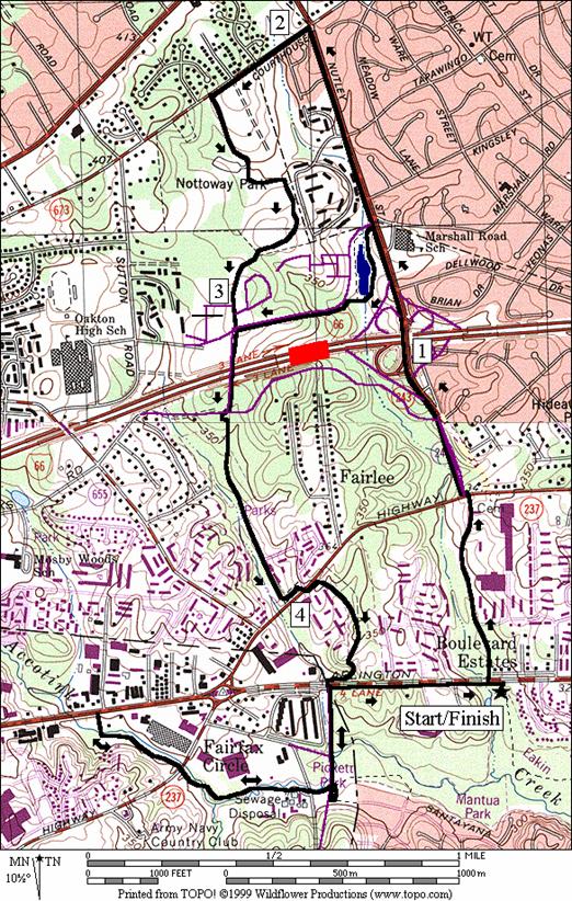
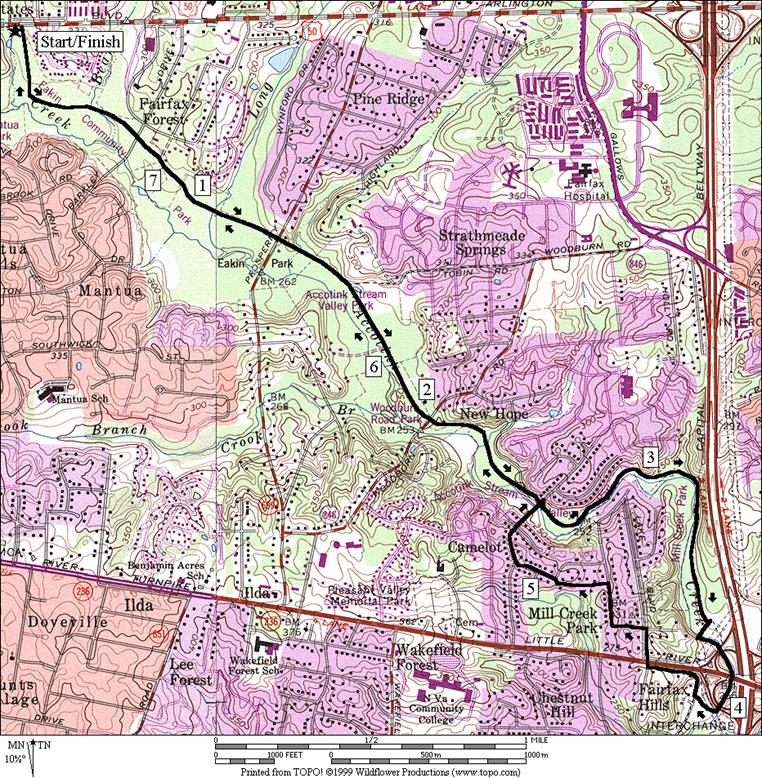
Eakin Community Park (7.9 miles, VII)
Going down through Eakin Community Park is enjoyable. Though the trail parallels Accotink Creek. It is however usually too far away from the creek to see the creek. Pines, Maples and Oaks grow healthily along the way providing shade. There are a few easy road crossings. After 2.5 miles, the trail is not maintained. Turn around if you like, but there is still some nice running further ahead. Continue downhill (it’s slight enough of a grade to be considered flat) in the woods, along the creek. At one point near a stream crossing, the now dirt trail gets a little rocky. Just before reaching the power lines, turn right and cross Accotink Creek on stones (don’t attempt this route if it has been raining recentlyBthe water may be high and the trail will be muddy). Turn left again, hopefully still dry, to follow the creek under highway access ramps and Little River Turnpike. Rte. 236. Emerge at Americana Park near the parking lot and ballfields. To loop back, climb the stiff hill on the Accotink Pkwy., then cross Little River Turnpike. Use rolling shaded suburban streets to get back to the Accotink valley at the point where the maintained trail begins and ends, then return the way you came.
Fairfax County Connector Trail (4.95, 3.8 or 6.95 miles, V, IV or VI)
For a commuter trail, the City of Fairfax Connector Trail (CFCT) is rather nice. Before getting there on this route, climb a less stimulating route along Nutley St. toward I-66. After crossing over I-66 a short option turns-off at Virginia Center Blvd. to round a small lake. After the lake the short route passes by the Vienna Metro station. Awkwardly, there=s no sidewalk in front of the station but the distance on the wide road is short before reaching the CFCT. On the regular route, continue straight on Nutley St, past the pond to Courthouse Rd. A narrow asphalt trail along it takes you to Nottoway Park. Nottoway is a mid-sized park with soccer fields, football fields, tennis and basketball courts. At the end of a parking lot, the CFCT begins. It only goes one-third a mile before becoming more like a sidewalk as it nears and passes the Vienna metro station. After crossing I-66 however, it descends through the woods of East Blake Lane Park, unpaved at first. The calm trail is interrupted by a road crossing at Lee Hwy., Rte. 29. At Arlington Blvd., Rte 50, the trail ends. Cross and turn left, using the wide shoulder for a short way before reaching the starting point at the Eakin Trail again. At the end of the CFCT, at the Arlington Bvld. and Lee Hwy. intersection, you can extend the route by going out and back along the Accotink. A bluestone trail picked-up at Thais Park crosses the creek twice before ending at Route 50; a little over a quarter mile west of Fairfax Circle. A narrow tunnel and an underpass gets around the busy road intersections on this trail.
Nearby and Connecting Zones
What to do Afterward
Food and Drink
Arigato Sushi - 703 352-9338
Viet Thai - 703 359-4433
Fudruckers 703 359-3798
Entertainment and Edification
Hunter House at
Oak Marr RECenter & Golf Complex - 703 255-5390
Distance: 7.9 miles
Rating: VII; mostly unpaved or dirt trails; shaded; hills near the turn around
0.0 from
1.5 gravel
trail on L to
1.6 trail
X on L to
2.05 Woodburn Rd (unmarked)
2.6 trail
X on L after underpass to
BR 2.95 on gravel; trail X on L (paved) goes uphill
3.2 cross tributary stream
3.45 trail X on R near a vertical vent pipe
R 3.7 trail X on R before power line clearing; cross the creek on stones (!)
L 3.75 after crossing; stay along creek; trail X on R goes along power lines
3.95 Little River Trkp, Rte 236; three underpasses
R 4.1 American Park parking; to the road
R 4.15 Accotink Pkwy (hill)
R 4.4 Pine Ridge Dr; cross Little River Trkp; Rte 236 (!)
L
L
R/L
R
R 5.3 trail X on R after the bridge over Accotink Creek
R 5.3 R
on Accotink Creek Stream Valley Trail at T (unmarked); go under bridge for
5.85 Woodburn Rd (unmarked)
6.3 trail
X on R to
6.4 gravel
trail on R to
City of Fairfax Connector Trail
Distance: 4.95, 3.8 or 6.95 miles
Rating: V, IV or VI; sidewalks and paved trails mostly; some long grades; mostly sunny
R 0.0 from Accotink Stream Valley Trail head, cross Arl Blvd, Rte 50 onto Nutley St
XS 0.55 at
1.0 begin bridge over I-66
<*
1.35
L 1.95 Courthouse Rd (asphalt path)
L 2.25 main
entrance road for
L 2.45 into parking lot after mansion on L
S 2.55 City of Fairfax Connector Trail (CFCT) head (paved)
S 2.85 on
3.1
>*
R/L 3.35 at
R/L 4.0 at
Circle Woods Dr; cross
4.25 trail X
4.3 road X
<**
CL 4.5 Arl Blvd, Rte 50 (! use shoulder)
4.95 Accotink Str Valley Trail head on R
![]()
*
UL 1.35 Virginia Center Blvd; trail X on L to lake loop trail; go clockwise
BL 1.6 leave the lake loop trail
L 1.65 Virginia Ctr Blvd (! use shoulder)
1.75
L 1.9 Vaden Dr; CFCT (pickup cues at mile 3.35 on 4.95 mile route)
![]()
*
S 4.5 cross
UL 4.75 into
L 4.8 tunnel
under
BL 5.25 at trail X; cross creek on wooden bridge
5.3 trail
X on L after underpass to
U
5.75 trail
X on R after underpass to
BR 5.8 trails merge after wooden bridge
R 6.2 after
tunnel under
R 6.5 Arl Blvd, Rte 50 (! use shoulder)
6.95 Accotink
Str Valley Trail head on R