Amongst
some of the higher land in
Getting There
From
the Capital Beltway (I-495), take I-270 headed west. About 14 miles from the beltway, take Exit
16,
Area
Routes
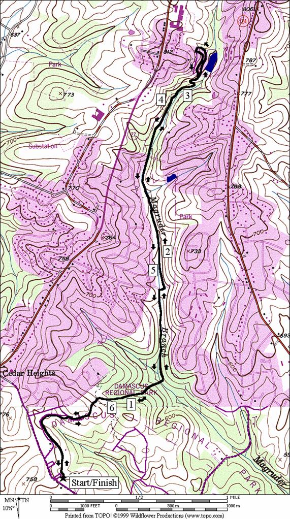
Magruder Branch Trail (6.9 miles, VIII)
This
hilly route is interesting. Starting at
close to 700 feet in elevation, the first three-quarters of a mile rolls and
climbs up to a ridge while being mostly in the open sun. In doing this, the paved Magruder Branch
Trail parallels a park road. A few water
fountains and restrooms can be found along it.
Unfortunately, there are no more water stops on the route until the
return. After reaching the ridge, the
next half mile of trail enters woodland and drops over 130 feet to the Magruder
Branch. The valley formed by the creek
is narrow and very shadedBunusual
for being over 560 feet in elevation in the county. The trail goes upstream along the creek,
crossing it many times and even being over it on longish wooden bridges where
it has become woodland marsh. Note that
the bridges can be slippery when wetBespecially
for bicycles). Gradually, the trail
climbs 130 feet over the next 1.75 miles.
A steep switchback climb up to
Nearby
and Connecting Zones
Seneca State Park, Lake Clopper
What
to do Afterward
Food
and Drink
Ledo Pizza - 301 482‑0700
Little
Far
Juliano's Brick Oven Pizza - 301 921-0199
Weis Colonial Bake Shop - 301 253‑9428
Entertainment
and Edification
Little
Distance: 6.9 miles
Rating: VIII; hilly, mostly wooded paved trails
L 0.0 trail head from the parking lot (water and restrooms at 0.25 miles)
0.55 cross park road near road X (portable toilet)
0.8 trail X on R to houses (unmarked)
0.8 trail X on L to houses (unmarked)
1.25 wooden bridge over Magruder Branch at bottom of hill; trail bears L after crossing going upstream
R 1.75 Sweepstakes Rd (!)
L 1.8 Magruder Branch Trail
2.4 trail X on L on wooden bridge; to houses
2.6 power line/fiber optic cable X
3.2 cross
L 3.5 Shelldrake Rd at trail end
L/R 3.7 onto
Magruder Branch Trail at
4.3 power line/fiber optic cable X
4.5 trail X on R on wooden bridge; to houses
R 5.1 Sweepstakes Rd (!)
L 5.15 Magruder Branch Trail
5.65 trail bears R on wooden bridge over Magruder Branch; at bottom of hill
6.1 trail X on R to houses
6.1 trail X on L to houses
6.35 cross park road near road X
6.9 parking (water and restrooms at 6.65 and 6.85 miles)