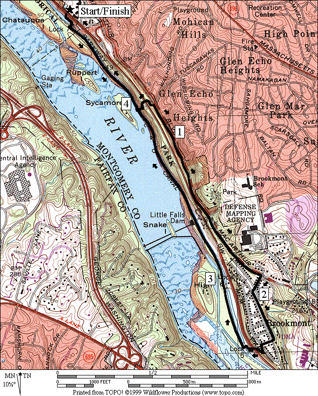
MacArthur Boulevard to Brookmont
|
|
C&O Canal, Lock 7
The
Getting There
From
Take the Capital Beltway (I-495), to the Cabin John Parkway headed south toward Washington D.C. The Parkway merges with the Clara Barton Parkway. Continue on it only one-half mile to a small parking lot, immediately off the Clara Barton Parkway on the right.
From
Use
MacArthur Blvd. to head north, away from the city. The Lock 7 parking lot cannot be accessed
when taking the Clara Barton Parkway heading north. From MacArthur, less than one-quarter mile
past the one-lane stone arch bridge, turn left onto an access bridge and
ramp. Turn left at the end of the ramp
to get on the Clara Barton Parkway headed south. Continue on it just less than one mile to a
small parking lot, immediately off
From
Take
the Capital Beltway (I-495) or
Area
Routes
This
loop combines the C&O Towpath with the MacArthur Blvd. Trail. The initial half mile is flat on the
towpath. A short climb over a bridge and
up to
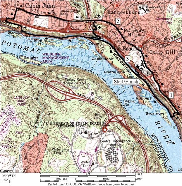
Glen Echo (3.3 or 5.55 miles; II or IV)
Start
this loop like the
to promote liberal and practical education, especially among the masses of the people to teach the sciences, arts, languages, and literature; to prepare its patrons for their several pursuits and professions in life; and to fit them for the duties which devolve upon them as members of society.
Malaria fears prevented the continuation of such gatherings. The park service does offer educational and entertainment programs of dancing, classes and workshops, theater and puppetry for children. The park did operate as an amusement park from the early 1900's until 1968. It has a playgrounds open to children now. See the hand carved Dentzel carousel still in operation four days a week in May through September.
Next to Glen Echo is the Clara Barton House. Even the ground between Glen Echo and the Clara Barton House is interesting. Interpretive signs describe how floods change a creek gorge there. Clara Barton chose her house and home to the American Red Cross in 1892. In an act perhaps showing her early recognition of a business practice more in vogue for the 1990's, she moved her home and organization headquarters from downtown D.C. to the suburbs. The house was used as a warehouse for disaster relief supplies. Clara Barton died in the house in 1912.
After
passing these historic places, the shorter route returns to the canal towpath
by turning left on a trail just before crossing the
Nearby
and Connecting Zones
C&O Canal, Carderock Recreational Area
What
to do Afterward
Food
and Drink
Glen Echo Pizza & Subs - 301 263-0414
Sushi Kanpai - 301 229-2526
Entertainment
and Edification
Glen Echo - 301 492-6229 or 301 492-6282
Clara Barton House - 301 492-6245
MacArthur Boulevard to Brookmont
Distance: 4.6 miles
Rating: III; crushed stone towpath, paved and unpaved trails
0.0 downhill
on the trail from the Lock 7 parking lot on the
L 0.05 C&O towpath
R 0.65 stairs
for metal bridge to go over the canal, the spiral bridge and the
R
CR
L 2.0 RR
grade in the median of
R
L
R 2.4 trail head to C&O towpath
2.5 spiral bridge
R 2.55 C&O towpath at Lock 5 (restroom)
2.95 Lock 6
3.15 trail X on L to intake of 3 mile long skirting canal
3.3 underpass pumping station aqueduct
3.95 stairs for metal bridge on L
R 4.55 wooden bridge over Lock 7 toward parking
4.6 Lock 7 parking
Distance: 3.3 or 5.55 miles
Rating: II or IV; crushed gravel on the towpath; paved trails
0.0 downhill
from the Lock 7 parking lot on the
L 0.05 C&O towpath
R 0.65 stairs
for the metal bridge over the canal, the spiral bridge and the
L
1.35 Oberlin
Ave & ramp to
1.75 Clara Barton Historic Site
<*
L 2.25 trail X on L to canal towpath; just before the stone arch bridge; (!) short steep downhill w/loose gravel
2.4 underpass parkway interchange
L 2.6 C&O Towpath at wooden bridge over the canal
>*
L 3.25 wooden bridge over Lock 7
3.3 parking
for Lock 7
![]()
*
2.25 trail
X on L to canal towpath; just before
2.35 end
of
2.4 Cabin John Trail head to Cabin John Park on R
2.5 ramp to Clara Barton Pkwy on L
3.0 Seven Locks Rd on R
L
R 3.2 onto
Riverside Dr at end of
BL
3.25 after underpass of
S 3.45 trail head to the canal at the end of Riverside Dr.
3.5 trail X on L to Lock 8 parking
L 3.55 C&O Towpath at wooden bridge over Lock 8 (pickup cues at mile 3.25 on 3.3 mile route)