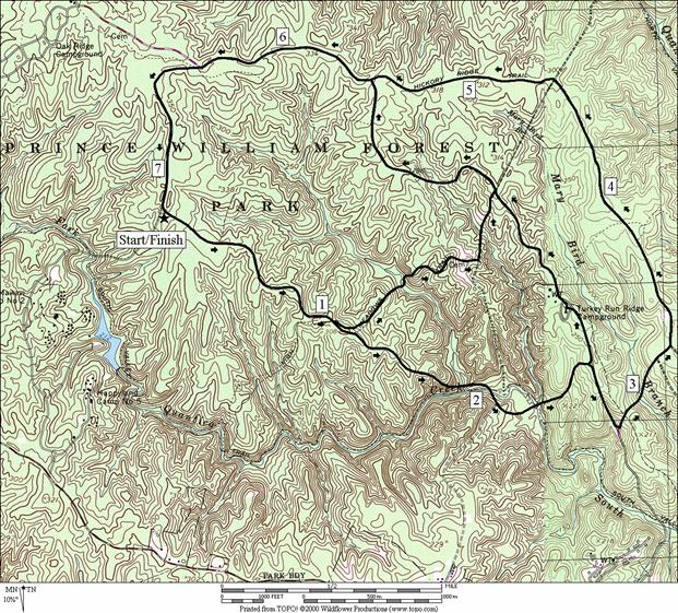
Prince William Forest Park, Parking G
From Parking area G in Prince
William Forest,
you can easily get to the vast majority of the park. The loop portion of the paved Scenic
Drive is the way that most use to get around however, many other trails and gravel roads create a vast
network. In the middle of the Scenic
Drive loop is the Turkey
Run Education Center. It offers hikes and other educational
programs about the history of the park by reservation. In the north part of the park is the Oak
Ridge Campground. Running on the trails
can vary considerably. In some places,
trails are hilly, narrow, winding and with awkward stones on the path. In others, trails can be relaxing and
meandering over level ground and forest.
The Virginia Hotfoot Half-Marathon has been held in the park.
Getting There
From the Capital Beltway
Take Exit 1, for Interstate 95 headed south. Go approximately 22 miles, then
take Exit 150 bearing right for Joplin Rd. Rte. 619. Take the second right into Prince William
Forest Park and pay an entrance fee at the gate. Turn left on the Scenic
Drive before the Pine Grove picnic area and Visitor
Center. When you reach the loop portion of the Scenic
Drive, bear right going up the hill. A bike trail soon takes-up the left side of
the road, making it one-way. 4.4 miles
from where you began the loop, turn right into Parking
area G. Routes start at the intersection
with the Scenic Drive.
Area Routes
Scenic Drive (7.2, 5.0, or 6.15 miles, VII, V or VI)
The paved Scenic Drive
is a favorite of cyclists mostly. Begin
by getting some of the hills out of the way.
Go around clockwise gradually dropping at first. The first option for shortening the loop is
at Parking area H.
The High Meadows Trail dips and climbs to the Taylor
Farm Road.
It passes the Taylor
cemetery; for the former residents. You
can then follow the Taylor Farm Road to the flatter the Old
Black Top Rd.
Skipping this for now, the Scenic Drive
drops quickly after Parking area H and eventually
makes two crossings of the South Fork Quantico Creek. Before the second however is the second way
to shorten the route. You can instead
take the Turkey Ridge Rd.
up to the Old Black Top Rd. From there it=s relatively flat to the Taylor Farm Rd. (where the first option joins) and the Scenic Drive. Skipping this option too, descend to where
the Scenic Drive loop
portion intersects the entrance/exit road that your
drove-in on. Turning left at this
intersection, climb to more level ground for the return trip. At the top, the bike trail can be used for
3.15 miles. Note that the Scenic
Drive is the main route through the park. Sections of it are without much shoulder and
must be shared with cars.
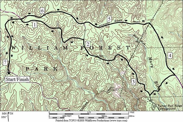
Mary Bird Branch (7.1 miles, VI)
Warm-up by taking the Scenic Drive
to the Oak Ridge Trail. The Oak
Ridge Trail is good for running on. It
gradually descends to a fern garden surrounding small streams, then climbs a
short hill up to the Old Black Top Rd. The gravel Old Black
Top Road descends to a stream and rises also,
crossing paths with the Taylor Farm Rd.
before reaching Mary Bird Trail. Mary Bird
Trail descends to a stream and climbs to the Scenic
Drive. It=s only a half-mile long and is a little
rocky at first. On the Scenic
Drive, use the bike trail to get back to the Oak
Ridge Trail. After passing it, a gradual
descent brings you back to Parking G.
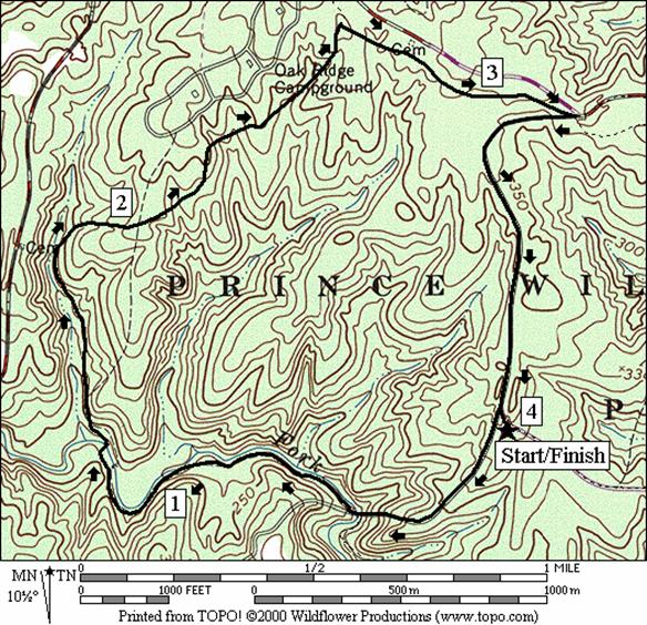
Oak Ridge
(4.0 miles, III)
Descend quickly on the gravel Mawavi Road. At the bottom, cross the
bridge over the South Fork Quantico Creek, and turn right on the South Valley
Trail, heading upstream. A little
of the trail tends to be waterlogged but there are wooden planks to get you
over the mud. Otherwise, the trail is
mostly flat and with good footing. After
crossing back over the South Fork Quantico Creek on a bridge, the trail leaves
the main body of water climbing a little more.
It also however, passes by beaver habitat. Visible when I was there in 1999, there was
one large lodge, and one smaller one.
Ferns also grace the trail. You
might see rocks sweat if it=s
humid out. The shade keeps them cool and
the hotter moist air condenses on them. The trail meanders a bit as it climbs
further but with each step even better footing is achieved. Pass close to the campground, then turn right on the Oak Ridge. A short way on the flat Oak Ridge Trail under
the oaks brings you to the Scenic Drive. Return less than a mile on the road back to
the Parking G.
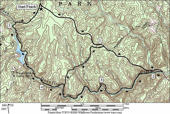
South Valley Trail (5.55 or 3.7 miles, VI or IV)
The South Valley Trail is the longest in the park. It goes nearly 10 miles from high points in
the northwest to a low point in the southeast of the park. Most of it follows the South Fork Quantico
Creek very closely. On this route, use
the Scenic Drive to start,
then either take a short cut on the High Meadows Trail, or go directly onto the
South Valley Trail. Using the High Meadows
Trail, cross over two small stream valleys before a final descent to the South
Fork Quantico Creek. The longer way on
the road takes you further out the drive then down a steep hill to the creek. This section of the South Valley Trail is for
hard core trail runners. The trail is
narrow (sometimes overgrown) and rocky.
There are good views of the rocky creek however, and you do pass along
one of the parks small lakes that are hard to get close to otherwise unless you=re renting the cabins. A climb up the Mawavi Road brings you back to
Parking G.
Nearby and Connecting Zones
Prince William
Forest, Parking G
Prince William Parkway Trail, Chinn
Park
What to do Afterward
Food and Drink
Dumfries Café - 703 441-1465
Chubb=s
Corner Café - 703 221-7771
Happy Eatery - 703 221-8889
Pizza Hut - 703 221-7171
Entertainment and Edification
Turkey Run
Education Center
- 703 221-7181
Weems-
Botts Museum
- Dumfries - an example of 19th century
housing - 703 221-3346
Leesylvania
State Park - 703 670-0372
Scenic Drive
Distance: 7.2, 5.0, or 6.15 miles
Rating: VII, V or VI; paved road with some steep
hills; unpaved & gravel on short routes
7.2
Mile Route
R 0.0 from
Parking G; on the Scenic Drive
<*
1.05 Parking
H; High Meadows Trail
1.85 South
Valley Trail (white blazes)
1.95 Liming
Lane on R
2.15 bridge
over S Fork Quantico Creek; begin climbing steep hill
<**
2.5 Turkey Ridge Rd
on L; top of hill
L 2.8 at
Rd X; to stay on Scenic Drive
loop; R is to park exit
2.85 Turkey
Run Ridge Trail
3.15 North
Orenda Rd on R
3.25 bike
trail begins; Pyrite Rd on
R
3.8 Lake
One Rd on R
3.85 Mary
Bird Branch Trail
4.6 Burma Rd/Taylor Farm Rd
5.45 Parking
F on R; Old Black Top Rd on
L
>*
6.4 bike
trail ends; Oak Ridge Trail; Oak Ridge Campground road on R
7.15 Mawavi Rd
on R
R 7.2 Parking
G on R

*5.0
Mile Route
L 1.05 High
Meadows Trail
1.45 bridge over creek
R/L 1.95 Taylor Farm Rd
2.1 wooden
bridge over stream
L 2.3 Old
Black Top Rd (pickup cues at mile 4.3 on 6.15 mile route)
**6.15
Mile Route
L 2.5 Turkey Run Ridge Rd
2.8 Turkey
Run Ridge Trail on R
BR 2.85 Turkey
Run Ridge Ed Center
2.9 Old Black Top Rd
2.95 Mary
Bird Branch Trail on R
3.0 High
Meadows Trail on L
3.45 Taylor
Farm Rd
>**
4.3 Oak
Ridge Trail on L
L 4.45 Scenic
Dr (pickup cues at mile 6.4 on 7.2 mile route)
Mary Bird
Distance: 7.1 miles
Rating: VI; paved road, gravel roads and trails;
some moderate hills; shady
L 0.0 from
Parking G; Scenic Drive
0.0 Mawavi Rd
on L
R 0.8 Oak
Ridge Trail; before road X
1.55 wooden
bridges over streams
1.65 wooden
bridge over stream
R 1.95 Old
Black Top Rd (gravel)
2.75 Taylor
Farm Rd
3.2 High
Meadows Trail on R
L 3.3 Mary
Bird Trail; descend
3.4 wooden
bridge over Mary Bird Branch
L 3.75 Scenic
Drive (use paved bike trail)
4.5 Burma Rd/Taylor Farm Rd
5.35 Old Black Top Rd
on L; Parking F
6.3 Oak
Ridge Trail; (bike trail ends); road X on R to campground
7.05 Mawavi Rd
R 7.1 Parking
G
Oak Ridge
Distance: 4.0 miles
Rating: III; gravel road, natural trails, and
paved road, moderate hills and good shade
L 0.0 from
Parking G; on the Scenic Drive
L 0.0 Mawavi Rd
on L
R 0.5 South
Valley Trail after crossing S Fork Quantico Creek on a bridge
1.2 beaver
dam
1.3 wooden
bridge over S Fork Quantico Creek before a
confluence
1.6 beaver
dam & lodge before fern garden
R 2.7 Oak
Ridge Trail
R 3.2 Scenic Drive
R 4.0 Parking
G
South Valley Trail
Distance: 5.55 or 3.7 miles
Rating: VI or IV; paved road, natural trail
and gravel road, difficult footing & some hills
5.55
Mile Route
R 0.0 from
Parking G; on the Scenic Drive
<*
1.05 High
Meadows Trail; Parking H
R 1.85 South
Valley Trail (SVT) (white blazes); S Fork Quantico Creek
2.0 wooden
bridge over tributary creek
3.25 beaver
dam
3.7 High
Meadows Trail on R
>*
4.3 wooden
arched bridge goes over S Fork Quantico Creek on
L
4.35 trail
X on L to dam
R 5.05 Mawavi Rd; begin climbing; bridge on L
R 5.5 Scenic Drive
R 5.55 Parking
G

*3.7
Mile Route
R 1.05 High
Meadows Trail
1.45 wooden
bride over stream
1.6 wooden
bridges over streams
R 1.85 South
Valley Trail (SVT); S Fork Quantico Creek (pickup cues at mile 4.3 on 5.55 mile
route)