Watkins Regional
Park
Watkins
Regional Park
is a mostly wooded park with ball fields, a nature center, campgrounds, a
carousel (by reservation), and an educational petting zoo. It=s
much like the better known Wheaton, and Cabin John Regional Parks maintained by
the Maryland National Capital Park and Planning Commission (M-NCPPC) as well as
other regional parks in Virginia. A
network of nature trails within it are well blazed and generally well
maintained. An equestrian trail under
high tension power lines bisects the park.
The park brochures show that the park was created in 1964 and named
after Robert M. Watkins, once a chairman of the M-NCPPC, in honor of his
efforts to for establishing open space in Prince
Georges County. Change in the park is underway. The size of it was doubled and a new entrance
with a covered bridge off of Landover Road,
Rte. 202, is planned. The park has a
comfortable and relaxed feeling to it.
Kids and their parents are found in most sections. Expect the park to get busier as more of Prince
Georges County=s farmland is converted to suburb.
Getting
There
From
the Capital Beltway (I-95), take Central Avenue
(Rte. 214) east and outside the Capital Beltway for 3.1 miles.
Turn right on Watkins Park Drive
(Rte 193) following it 0.85 miles. Turn
right into the Park Entrance.
Immediately, turn right again on Old Enterprise
Road. Again
immediately, turn left before the gate that closes Old
Enterprise Road.
Turn right at the first parking area which is for the Administration
Building, then right again to the
start at the end of the parking lot.
Area
Route
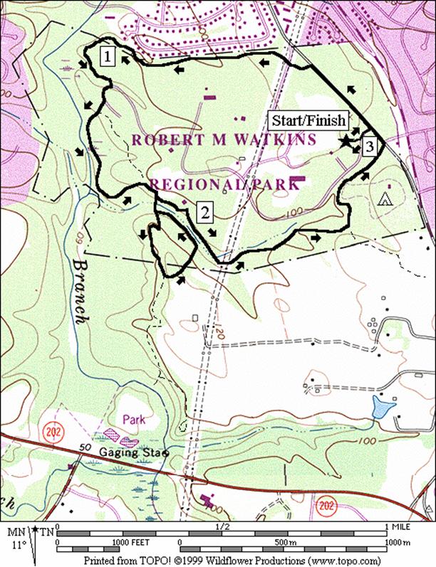
Spicebush
Trail (3.05 or 3.55 miles, II or III)
The
main nature trail through the park is the 2.9 mile Spicebush Trail. What=s
nice about this trail is that for a wooded trail in the Washington
area, this one is very flat. The trail
is marked with a blue blaze. The route
initially is on the part of Old Enterprise Rd.
that is closed to traffic. After crossing the power lines, it skirts
along the park=s western
borders with the backyards of houses visible.
A brief pass through a picnic parking lot marks the beginning of the
wetland area. The Wetland Trail (yellow
blaze) is concurrent with the Spicebush trail here. You may as I did, spy an owl or surprise a
group of as many as 12 deer here in the middle of a spring day. You may also however, get bit through your
clothes by occasional swarms of hungry mosquitoes. After leaving the wetland area, a group of
intersecting trails is encountered near the Watkins
Nature Center.
A
half mile add-on loop option is available near the Nature
Center. The Upland Trail (dark green blaze) climbs up
a small bluff that overlooks wetlands of the Western Branch, a tributary to the
Patuxent River. The complete and blazed Upland Trail actually
goes back down the hill to the edge of the wetland and along it a ways but the
described route skips that to stay on the hill.
Additional out and back trails connect to the Upland
trail. They could be connected to the
Equestrian Trail for a longer add-on loop, but the Equestrian Trail goes
through cultivated fields and is not yet well defined in that portion of the
park.
After
the nature center, the Spicebush Trail crosses several streams on wooden
bridges as it gradually climbs. After a
detour around the campgrounds, it completes the loop and returns to Old
Enterprise Rd. at the park entrance. The Spicebush Trail appears to be used
relatively little compared to other regional parks. In springtime, apple acorns grow right in the
middle of the trail in some places while occasionally gumball seeds cover the
trail in others. Bicycling is not
allowed on the trails.
Nearby
and Connecting Zones
Patuxent
River Park/Merkle Natural Resource Management Area
Foxhill
Park, Bowie,
Maryland
What
to do Afterward
Food
and Drink
picnic
Entertainment
and Edification
Six
Flags - water and amusement park - 301 249-1500
Merkle
Natural Resource
Management Area Visitor
Center - 301 888-1410, TTY
410 974‑3683
Spicebush Trail
Distance: 3.05 or 3.55 miles
Rating: II or III; mostly unpaved blazed
trails through parkland
3.05
Mile Route
R 0.0 east
end of parking lot; wooden stairs& path toward the park entrance
L 0.05 L
at parking and L on Old Enterprise Rd;
pass around the closed gate; Spicebush Trail is on the road; follow the blue
blazes
BL 0.35 leave
Old Enterprise Rd. onto
trail
0.4 power
lines; Equestrian Trail
1.0 trail
X on R to community park
R 1.2 to
stay on Spicebush Trail; toward wooden bridge and parking
R 1.25 picnic
parking (water & restrooms)
R 1.3 into
woods to stay on Spicebush Trail; follow blue blazes
1.35 Wetland
Trail and Spicebush Trail are concurrent; blue & yellow blazes
<*
R/L 1.85 R at
T; L at trail X to stay on the Spicebush Trail; Nature
Center
>*
R 1.95 at
billboard and trail X to stay on Spicebush Trail; blue & red blazes
L 2.05 trail
X; follow blue blaze
BL 2.15 at
trail X on R just after power lines
L 2.65 after
wooden bridge to go around campground; follow blue blazes
L 2.9 Old
Enterprise Rd. on shoulder
L/R 2.95 L on
park road completes loop; leave Spicebush Trail; R on paved path to Administration
Building parking lot
3.05 Administration
Building parking lot

*3.55
Mile Route
R 1.85 R
at T; over the wooden bridge to the Upland Trail (dark green blazes); and up
the hill
S 1.95 leave
Upland Trail as it goes down the hill on the R
S 2.05 Upland
Trail merges from the R; Beaver Pond Trail goes R
R 2.3 complete
Upland Trail loop; to wooden bridge
R 2.35 Spicebush
Trail toward the nature center (blue blazes) (pickup cues at mile 1.95 on 3.05 mile
route; end 3.55 miles)