Washington, Baltimore & Annapolis Trail, Glenn Dale


Over the course of 1999 and 2000,
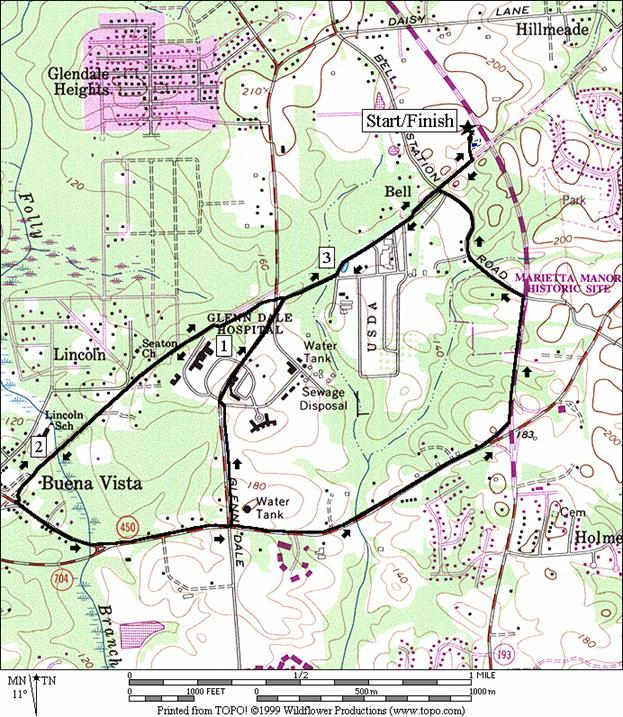
 Prince Georges County added another asset for its citizens to enjoy.  The Washington, Baltimore & Annapolis Trail (WB&A) was created after a requests by citizens.  It=s not the first time people traveled this pleasant corridor.  Electric trains once took Washingtonians to and from Baltimore over this route.  Bridges and tunnels for the 10 foot wide paved trail keep encounters with auto traffic minimal.   This trail is much smaller, but similar in nature to its more well known predecessor, the Washington & Old Dominion Trail in Virginia. Glenn Dale is near the western end of the currently 5.6 mile long WB&A.  The trail stops just after Race Track road for now but is one day expected to continue on across the Patuxent River, east into Anne Arundel County.  The eastern ends of the current trail are the most scenic and bucolic. 


Getting There


From the Capital Beltway (I-95), take Rte. 450 north.  Stay to the right after the first light (it=s within a quarter mile of the beltway) and turn right at the next onto Lanham Severn Road (Rte. 564).  Approximately 2.75 miles after getting on Lanham Severn Road, turn right at the light onto Glenn Dale Blvd., Rte. 193.  After approximately 1.3 miles, turn right into the Glenn Dale Community Center and Splash Park.  The trail head is to the left, between the pond and the Splash Park. 


Area Routes


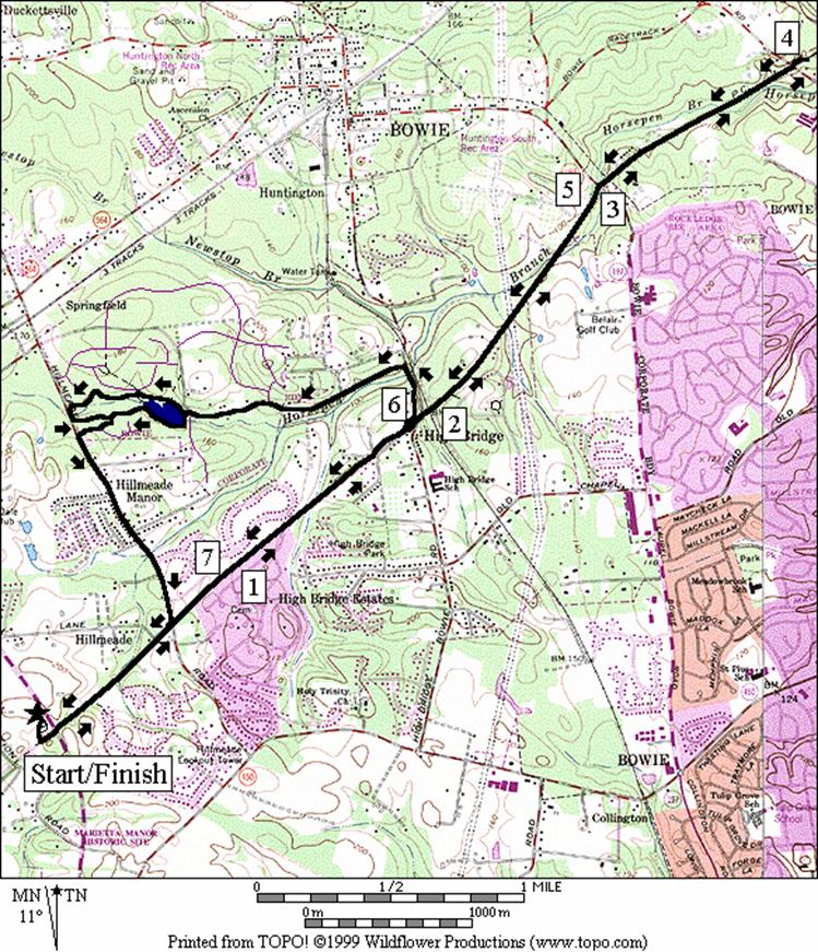
Horsepen Branch (7.9, 5.1 or 5.45 miles, VII or IV)

There are many options for running northeast on the WB&A Trail.  Go out and back as far as Race Track Road or leave the trail for a loop through the community park at Northridge.   Staying on the WB&A for an out and back route is the most pleasant way to go.  After tunneling under Glenn Dale Blvd. the trail skirts along the back yards of several housing developments.  Mostly however, trees obscure the houses.  The long straight trail is generally downhill going out toward Bowie.  Besides crossing some fields and farms, it crosses Horsepen Branch, a tributary to the Patuxent River, several times.  It=s also mostly sunny, except for the last mile to Race Track Rd.  A few bridges, tunnels, and power lines serve as landmarks and get you across roads and railroads.  The nicest parts are at the farthest end, both near Laurel Bowie Rd., Rte. 197, and Race Track Rd.  From the Bowie end of the trail, some rougher running on the unimproved Race Track Spur railroad grade will connect you to the Fran Uhler parks. 


The loop off the WB&A Trail through the Northridge community requires the use of some road shoulders.  A very short section on High Bridge Rd. is the worst of these, combining traffic and a limited sight distance curve.  Use caution if you choose this loop.  Other road shoulders on the loop are wide and paved.  In Northridge, the Maryland National Capital Park and Planning Commission has created a small lake and a network of paved trails.  Go clockwise around the lake for the shortest way back to the WB&A and Glenn Dale, or go counter-clockwise for a slightly longer paved trail going the woods.  The loop trail in the community park is 1.13 miles long.  Combining the out and back to Race Track Rd. with the most direct extension through Northridge lengthens the run to 9.3 miles. 


Electric Avenue (3.6, 4.25 or 4.35  miles, III)

When going southeast on the WB&A Trail toward Lanham, the way is also pleasant. Short sections however are either on a paved road or are closely parallel to one.  About one mile out, you=ll pass a small wetland and parking area.   After crossing over a creek named Folly Branch, you=ll soon reach Annapolis Rd., Rte. 450.  Decide if you want if you want to go back the most pleasant way, which is back the way you came, or if you want to extend the route by using paved trail along Annapolis Rd.  One of the ways back from Annapolis Rd. passes the abandoned and now dilapidated Glenn Dale Hospital campus.  The other passes Marietta Mansion, former home of Gabriel Duvall, Associate Justice on the U.S. Supreme Court in 1811.  The home was once a 650 acre plantation estate. 


Nearby and Connecting Zones


Fran Uhler Natural Area/Race Track Spur

Foxhill Park, Bowie, Maryland

Beltsville Agricultural Research Center


What to do Afterward


Food and Drink

La Hacienda (301) 262-8800


Entertainment and Edification

Marietta - plantation home of Gabriel Duval, Associate Justice on the Supreme Court in 1811; 301 464-5291, TTY 301 277-8456

National Aeronautical Space Administration (N.A.S.A.) Goddard Space Flight Visitor Center - 9AM - 4PM daily - 301 286-2000

Dorsey Chapel - rural African American community church from circa 1900 - 301 352-5544, TTY 301 669-2544


Horsepen Branch

Distance:          7.9, 5.1 or 5.45 miles

Rating:  VII, IV or IV; mostly sunny, paved railroad grade trail; some hills in Northridge


7.9 Mile Route


          0.0     trail head at the parking lot


BL     0.0     go between the pond and the pool


L        0.05   trail X at T; WB&A Trail

          0.1     tunnel for Glenn Dale Blvd, Rte 193

          0.3     trail X on R to Guinevere Pl; Mile Mark 2

          0.65   trail X to Hillmeade Rd (bridge ahead)

          1.35   Mile Mark 3

          1.6     trail and road are split by fence

          1.7     trail bears L up a small hill at Cedar Rd

<*

          1.85   trail X to High Bridge Rd (the wooden bridge over High Bridge Rd is ahead)

          2.0     at end of bridge over RR

          2.05   trail on R to Old Chapel Rd

          2.35   Mile Mark 4

          2.5     power line crossing; Rd X

          3.0     begin the bridge over Rte 197

          3.35   Mile Mark 5


U       3.95   trail ends at parking after bridge under Race Track Rd.

          4.6     Mile Mark 5

          4.95   end of the bridge over Rte 197

          5.45   power line crossing; Rd X

          5.6     Mile Mark 4

          5.85   trail X on L to Old Chapel Rd

          6.0     begin the bridge over High Bridge Rd

          6.05   trail X on R to High Bridge Rd

          6.6     Mile Mark 3

          7.25   trail X on R to Hillmeade Rd

>*

          7.6     trail X on L to Guinevere Pl; Mile Mark 2

          7.8     tunnel Glenn Dale Blvd, Rte 193


R       7.85   trail X on R; Glenn Dale Comm Ctr


R       7.9     trail X at T; to parking


*5.1 Mile Route


L        1.85   trail X to High Bridge Rd


CL     1.9     High Bridge Rd; (! blind curve & narrow shoulder)


L        2.15   Fletchertown Rd (use L shoulder)

          2.7     Quetzal Rd on R


CL     3.0     cross Quinsberry Rd, L on paved trail through the gate to the lake; Northridge Community Park

<**

L        3.0     trail X; go around the lake

          3.25   trail X on R goes toward gazebo

          3.3     trail X on L (unmarked)

          3.35   trail X on L (unmarked)


L        3.4     trail X on L (unmarked) to Quantum Leap Lane

>**

R       3.45   Quick Fox Lane


L        3.55   Hillmeade Rd


CR     4.4     Daisy Lane


L/R    4.45   L to WB&A trail; R on WB&A trail (pickup cues at mile 7.6 on 7.9 mile route)


**5.45 Mile Route


R       3.0     trail X; go around the lake

          3.1     trail X=s on R go up hill to parking

          3.25   trail X on R toward Quintette La (unmarked)


R       3. 25  trail X on R leaves the lake area

          3.55   trail X on R (unmarked)


R       3.75   trail X on R to (unmarked) to Quantum Leap Lane (pickup cues at mile 3.45 on 5.1 mile route)


Horsepen Branch


Electric Avenue

Distance: 3.6, 4.25 or 4.35  miles

Rating:           II, III or III ; mostly paved railroad grade trails; mostly flat and sunny


3.6 Mile Route


       0.0   trail head at the parking lot


BL  0.0   go between the pond and the pool


R     0.05 trail X at T; WB&A Trail

       0.2   Bell Station Rd (! blind X)


BR  0.3   paved trail ends; use shoulder of Old Pond Dr (unmarked)


BR  0.6   at Rd X to stay on Old Pond Dr; pond on L


BR  0.75 onto paved WB&A Trail; Glenn Dale Rd ahead

       0.8   Mile Mark 1

       0.9   parking on R; wetland ahead


CL  1.0   to stay on WB&A Trail at Electric Ave


S     1.3   cross Electric Ave to stay on WB&A Trail

       1.5   wooden bridge over Folly Branch


BR  1.7   bear R on driveway to stay on trail

<*

U    1.8   Old Annapolis Rd


BL  1.85 bear R off driveway to stay on trail

       2.05 wooden bridge over Folly Branch

       2.3   cross Electric Ave; trail now parallels it


BR  2.6   WB&A trail crosses Electric Ave to wetland/parking area

       2.8   Mile Mark 1; Glenn Dale Rd


BL  2.85 onto Old Pond Rd; paved trail ends

>*

BL  3.0   at Rd X to stay on Old Pond Rd


BL  3.3   paved WB&A Trail continues

       3.4   Bell Station Rd (blind X)

>**

L     3.5   trail X on L; Glenn Dale Comm Ctr


R     3.6   trail X at T; to parking


*4.25 Mile Route


R/L 1.8   paved trail along Old Annapolis Rd, Rte 450

       2.0   concrete bridge over Folly Branch

<**

CL  2.45 Glenn Dale Rd


BR  3.1   Old Pond Rd

       3.15 WB&A Trail merges from L (pickup cues at mile 3.0 on 3.6 mile route)


**4.35 Mile Route


       2.45 Glenn Dale Rd


L     3.35 Glenn Dale Blvd Rte 193; trail ends; use shoulder

L     3.7   Bell Station Rd (! blind curve ahead)


R     4.15 WB&A Trail (pickup cues at mile 3.5 on 3.6 mile route)


Electric Avenue