White Marsh Park
|
|
The
approximately 50,000 residents of the city of
Getting There
From
the Capital Beltway (I-95) in
Area
Routes
When
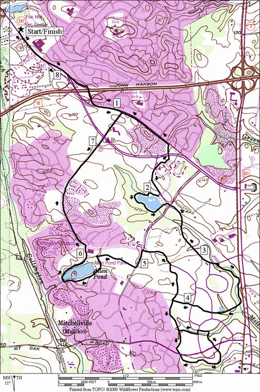
Allen Pond (8.4 or 10.15 miles, VII or VIII)
Using the trail along Collington Rd., Rte. 197, this route heads south over Rte. 50. Once across, it follows along Old Collington Rd. then passes through neighborhoods to an unnamed pond created in 1998 at what will become the Bowie New Town Center. Going further south across Mitchellville Rd., the route takes one of Bowie=s newest trails along a wooded stream valley and parallels Robert Craine Hwy., Rte. 301. An optional lollipop route extension uses trails through a subdivision. More trails are planned near this subdivision. Coming back on roads, the route finally reaches Allen Pond for a partial loop around the lake. The loop around the attractive lake, is frequently used by families with young children, walkers and runners. It is 0.68 miles around. The trail along Northview Dr. brings you back to the trail at Old Collington Rd. where you can return to Foxhill Park.
Nearby and Connecting Zones
Fran Uhler Natural Area/Race Track Spur
Beltsville Agricultural Research Center
Watkins Regional Park
What
to do Afterward
Food and Drink
Beijing Restaurant - (301) 249‑4242
Don Pablo=s - 301 809-6720
International House of Pancakes, Rte. 450 (IHOP)
Einstein=s Bagels, Rte. 450
Entertainment
and Edification
Bowie Baysocks - Baseball - 301 805-6000
Belair Mansion - Thursday-Sunday 1-4PM - 301 809-3089
Belair Stable - built in 1907 - 301 809-3089
Prince Georges County Genealogical Library - 301 262-2063 - open 10AM-dusk on Wednesday except the first Wednesday of the month; last Saturday of the month 1-5PM)
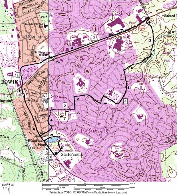
White Marsh Park
Distance: 6.0 miles
Rating: V, rolling to flat paved trails and sidewalks
6.0 Mile Route
R 0.0 from the white posts on the trail at the parking entrance
0.15 gravel road and pond on R
0.25 Faith La
0.7 Long Ridge Rd
BR 0.9 onto bike trail after crossing (old)
1.75
R 2.7 at Race Track Rd cross Annapolis Rd to the trail head in White Marsh Park
2.8 paved TR X on R
3.2 paved TR X on L
L 3.6 Stoneybrook Dr
R 4.05 trail head to Somerset Neighborhood Park (unmarked)
L 4.25 Stonehaven La
R 4.35 Starlight La at T
CL 4.7 Belair Dr at T
R 4.85 Tulip Grove Dr
5.05 Belair Mansion on L
L 5.15 Foxhill La
R 5.35 Faith La
L 5.5 paved trail along Collington Rd
L 5.6 gravel road before pond
BR 5.8 stone bridge over pond
BR 5.85 at trail split after bridge
R 5.95 R at parking lot toward exit
6.0 white posts at trail
White Marsh Park
|
|
Allen Pond Park
Distance: 8.4 or 10.15 miles
Rating: VII or VIII, rolling to flat paved trails and sidewalks
8.4 Mile Route
L 0.0 from the white posts on the trail at the parking entrance
0.6 begin bridge over Rte 50
1.05 Northview Dr & trail X on R
R 1.45 Holiday La (unmarked); at the end of Old Collington Rd
1.55 cross Rte 197 (!)
R 1.6 English Oaks Ave
L 1.75 Evergreen Ave
CL 1.8 Excalibur Dr
R 1.95 trail X on R; to go around lake
R 1.95 lake trail
R 2.45 trail X on R toward Excalibur Dr
R 2.5 Excalibur Dr
2.55 cross Mitchelleville Rd
2.7 City of Glen Allen Park on R
R 3.15 trail X on R after Eagle=s Nest Dr
3.85 Applegreen La (unmarked)
4.05 Atlantis Dr (unmarked)
<*
R 4.15 TR X on L & R (unmarked)
>*
4.4 sharp turn R in trail (possible future trail will go S)
L 4.5 Atlantis Dr (unmarked); S will be bike trail through nature preserve
L 4.9 Mitchelleville Rd
R 5.05 Allen Pond Park; park road
L 5.35 lake trail around Allen Pond
R 5.75 at T for lake loop; Nottingham Dr
5.8 TR X on L to Nottingham Dr
BL 5.95 at brick walk on R; leave lake through parking lot
CL 6.15 Northview Dr
7.05 cross Collington Rd (Rte 197)
L 7.35 trail X at Old Collington Rd
7.65 begin bridge over Rte 50
8.4 second white posts on trail
![]()
*10.15 Mile Route
L 4.15 trail X; L & R
4.55 trail X on L (return route)
4.7 Mount Oak Rd
BR 5.15 at fork in trail (unmarked)
5.2 trail X on R
5.25 Mount Oak Rd
L 5.35 trail X on R
L/R 5.45 Arden Forest La; stay on trail
R 5.6 at T
5.9 trail X; L & R (pickup cues at mile 4.4 on 8.4 mile route; end is 10.15 miles)
Allen Pond Park
|
|