Carderock is probably best known for its ample rock climbing opportunities. Rock jocks train here by top-roping, bouldering and soloing on the up-to 80 ft. high cliffs. Some of the climbs begin right in the river when the water is high. Though there are many challenging climbing routes, a good number of easy beginner climbs make it a popular place. After climbing Beginners’ Crack (with belayer, safety rope, harness and a teacher), many first-time climbers of the area became hooked on the sport. When the rock gets too busy, or a break is needed, some take a break by running or riding up and down the canal towpath. Picnic areas are also located in the park which is maintained by the National Park Service.
Getting There
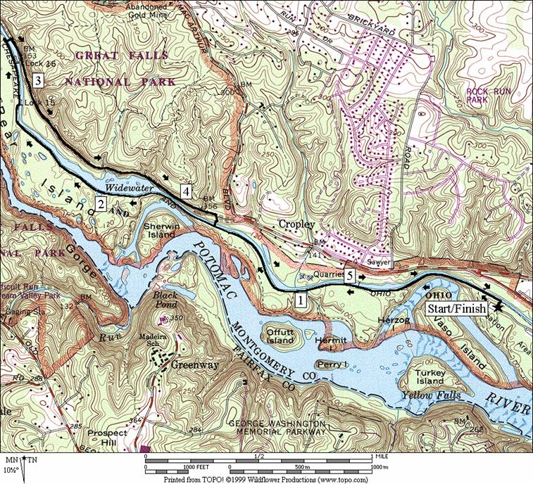
Take the Capital Beltway (I-495), to the Cabin John Parkway headed west, outside the beltway. Make a right on the first exit which is for both Carderock, and the Naval Surface Warfare Center (Carderock Division). Turn left at the stop sign at the end of the ramp to cross the parkway. After passing under the canal, turn right and proceed to the last parking zone. The trail head is on the right as you enter, opposite the restrooms on the left. The trail to the rock on the left.
Area
Routes
This route is an old favorite of many runners. The Widewater is one of the most picturesque sections of the canal. It’s a section that widens to lake-size proportions with rocky shores and small islands. The man-made body of water is often canoed-in and fished. Dogs jump in from the steep shorelines to chase sticks then return to splash passers-by as they shake off the cool waters. The sun sparkles off it. Even getting there from Carderock is fun. Take the towpath north from the parking. Only a quarter mile from the start, the towpath and canal sit atop a retaining wall, that drops to the river about 50 vertical feet below. The views are excellent. A few stretches of the canal just ahead offer prelude to the real Widewater with placid wide areas and gentle man-made curves. In autumn, the leave colors are seen twofold due to the reflections.
Sections of the Billy Goat trail appear on the left before and at the Widewater. Cycling is not allowed on them. They make for good hikes but most will find them too rocky for running. Note that near the Widewater, the distance between mile markers 12 and 13 is actually only 0.84 miles. The next marked mile (which on this route, you won’t cover completely) from 13 to 14 is long 1.11 miles. Most of the mileposts on the C&O towpath are correct but a significant number of them are off. As one gets toward the end of the Widewater, the towpath is briefly changed from its usual crushed gravel surface to angular and blocky, rocks. These will slow you down and cause cyclists to have to carry their vehicle but offer no real challenge to walk over.
The return route uses the opposite bank of the Widewater. Crossing the canal is accomplished via a foot bridge above Lock 16 and near the start of the Billy Goat trail Section A. This route, cited by the park service as a detour route for cyclists wishing to avoid the rocky section of the towpath, still requires you to carry a bike up stairs to the bridge. Once across, the return trail is shady and wide with a rough gravel surface. Due to the trees the views of the water are more obscured, except in Winter. Where views do open-up however, they are sometimes better because of the higher vantage point. After 1.35 miles, rejoin the towpath by crossing a wooden bridge after the Widewater ends and return on the towpath.
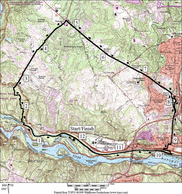
Potomac (12.2 or 12.3 miles; X)
For those looking for a long route but not wishing to go out then double-back on the canal, this loop offers you an alternative. Take the towpath north up to the bridge just before the Widewater. Cross the canal there and continue heading north on the trail paralleling the canal. After only a hundred yards, look for a yellow blazed unpaved trail on the right, which goes around the fence enclosing the water pumping machinery. Climb the Valley Trail to the Gold Mine Trail (see the description for the Gold Mine Trail in: C&O Canal, Great Falls). I saw plenty of deer and a fox while on this trail. It’s slightly easier than going up via the Angler’s Spur Trail though both are significant climbs. Follow the Gold Mine Trail and then the Fall Rd. Spur Trail to the gold mine and MacArthur Blvd. After crossing MacArthur, use the paved trail along Falls Rd. This trail is partly shady, partly sunny, rolling but graded and wide. It crosses Falls Rd. three times before arriving at the center of town in Potomac. Once there, cross River Rd. and turn right onto another paved trail. This trail is not as nice as the one along Falls Rd. Its narrower, and has few trees separating and sheltering it from the road. It can be hot on a sunny warm day and has no water available along it. After an initial climb, it very gradually descends. Eventually, the trail runs out altogether and use of the shoulder along River Rd. is necessary. The shoulder is wide and relatively safe compared to some. Many pedestrians use it.
At
the bottom of a hill after starting to use the shoulder, you’ll pass the
Nearby
and Connecting Zones
C&O Canal, Great Falls, Maryland
What
to do Afterward
Food
and Drink
Angler’s
picnic
Entertainment
and Edification
Billy Goat Trail hikes
rock climbing instruction
canoeing and kayaking
Distance: 5.7 miles
Rating: V; generally flat crushed stone; partial tree cover
0.0 from the parking lot at Carderock
L 0.05 C&O towpath
0.1 Billy Goat Trail Section C on L
0.5 Billy Goat Trail Section B on L
0.7 wooden bridge over canal
1.35 Billy Goat Trail Section B on L
1.45 wooden
bridge over canal to parking and Angler’s
1.75 begin Widewater
1.85 Billy Goat Trail Section A on L
2.0 Mile Marker 13 and bridge (from Mile 12-13 is only 0.84 miles)
2.4 begin rocky towpath (!)
BL 2.55 trail splits
2.6 trail merges at wooden bridge; Lock 15; end Widewater
2.8 Lock 16
UL 2.9 up stairs to cross bridge over canal
R 2.9 at T at end of bridge
3.15 Lock 16 Spur Trail on L
4.15 Angler’s Inn Spur Trail on L after fence enclosing water pumping machinery
R 4.2 down stairs on R toward bridge over the canal (portable outhouse, phone at parking)
L 4.25 at T on C&O towpath
4.35 Billy Goat Trail Section B on R
5.05 wooden bridge over canal
5.2 Billy Goat Trail Section B on R
5.6 Billy Goat Trail Section C on R
R 5.7 trail X on R toward parking
5.7 Carderock parking
Distance: 12.2 or 12.3 miles
Rating: X; flat shaded towpath; unpaved trails w/early hills, sunny paved trails; roads
0.0 from the parking lot at Carderock
L 0.05 C&O towpath
R 1.45 wooden
bridge over canal toward parking and Angler’s
L 1.5 BL to stairs (portable toilet) and L again at top; onto gravel road
R 1.55 Angler’s Inn Spur Trail (yellow blaze); before fencing/water pump
BR 1.6 Valley Trail (begin climb)
R 2.25 Gold Mine Loop Trail (blue blaze)
R 2.65 Falls Rd Spur Trail (blue blaze)
2.75 abandoned gold mine/top of hill
S 2.8 cross
3.05 trail crosses Falls Rd
3.8 trail crosses Falls Rd
4.1 trail crosses Falls Rd
CR 4.7 River Rd (use sidewalk/trail)
7.0 Clewerwall Dr; (!) trail ends; use shoulder; downhill
7.35 Cabin John Tr head on L after bridge
XS
CR
<*
8.0
8.35
>*
8.45 underpass Capital Beltway, I-495
8.55
CR
L
R 9.3 onto
BL 9.35 after
underpass of
S 9.55 trail
head to canal at end of
R 9.65 C&O Towpath at bridge over Lock 8
10.0 Lock 9
10.05 Lock 10
10.25 Lock 11
10.55 Lock 12
10.65 Lock 13; underpass beltway, I-495
10.75 Lock 14
11.2 Billy Goat Trail Section C on L
L 12.15 trail X on L toward parking
12.2 Carderock
parking
![]()
*
L 8.0 Cabin John Trail
8.4 cross small stream on stones
L 8.5 Seven Locks Rd (pickup cues at mile 8.45 on 12.2 mile route)