Baltimore & Annapolis Trail -Earleigh Heights
At
just under 14 miles long, the Baltimore
& Annapolis (B&A) Trail
covers most of the distance between Annapolis, Maryland
and the Baltimore Washington International Airport (BWI). Almost all of it is on an old railroad grade.
At the northern, BWI end, a 1.5 mile connector trail links it with the 10.6
mile BWI Trail. The B&A trail parallels Governor Ritchie Highway,
Rte. 2. In the north, the B&A
passes through Glen Burnie. Going south, the suburbs lining the trail get
less frequent and are replace by trees.
The trail does pass right next to several shopping areas including the
Marley Station Mall. Most of it is
composed of flat, long straight stretches that are ideal for in-line
skating. Near the middle of the trail at
Earleigh Heights,
a ranger station and parking area make a convenient place to start
exploring. Kinder Farm
Park is also nearby with a very
nice and new 2.4 mile loop trail. South
of Earleigh Heights, the B&A goes through the quiet town of Severna
Park. The
southernmost end is nearly rural. The
trail unfortunately does not actually connect all the way to Annapolis
because of private property between Rte. 50 and the Old
Severn River Bridge.
Getting
There
From
the Capital Beltway (I-495), take the Baltimore
Washington Parkway (I-295) north toward Baltimore. After 15 miles, exit to Route 100 headed
west. After 8 miles, turn right onto Governor
Ritchie Highway, Rte. 2. Approximately 3 miles later, turn right onto Earleigh
Heights Rd.
Note that Magothy
Bridge Rd is on the left at the same
intersection. Park on the left or right
a quarter mile later after crossing the B&A trail.
Area
Routes
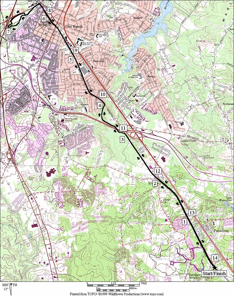
Glen
Burnie (14.05 miles, X)
Very
few hills and many long straight stretches characterize this route. The long, mostly out-and-back lollipop course
has a few water opportunities. Kids
occasionally sell lemonade or even sports drinks also. There are some convenience stores in
convenient places too. Begin from the
ranger station by crossing Earleigh Heights Rd. Pass the occasional side trails. Some of these go to Kinder
Farm Park
(see below). There are a few road
crossings some of which require care.
One of the few hills is the ramp to the trail bridge over Rte. 100 to
Marley Station Mall. The mall is an
alternative starting place for those wanting a shorter route. In Glen Burnie, the
trail passes some older and now decrepit retail places. The town center is passed at the intersection
with Crain Hwy, Rte.
3. At the end of the B&A Trail, turn
left to follow a connector trail toward the BWI Trail. Before getting there, turn around on the
short loop trail in Sawmill Creek
Park, and take advantage of water
and restrooms. Return the way you
came.
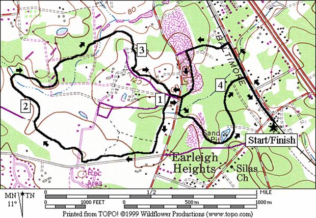
Kinder
Farm Park
(4.3 miles, III)
The
Kinder Farm
Park is being newly fitted with many
facilities. Ballfields
are most prevalent but the trail is the nicest feature. It is paved and loops the park. Runners love it and few know about it. Some easy hills make it more challenging for
in-line skaters but it is wide and smooth.
What=s nice
about it are the gentle curves and the way it follows the landscape of the old
farm. Open fields, scattered trees, and
a few creeks are on the way. From the
ranger station at Earliegh
Heights, safe access to Kinder
Farm Park
is made possible by using spur trails off the B&A Trail. They lead to bordering neighborhood where you
can use sidewalks to get to and from the park.
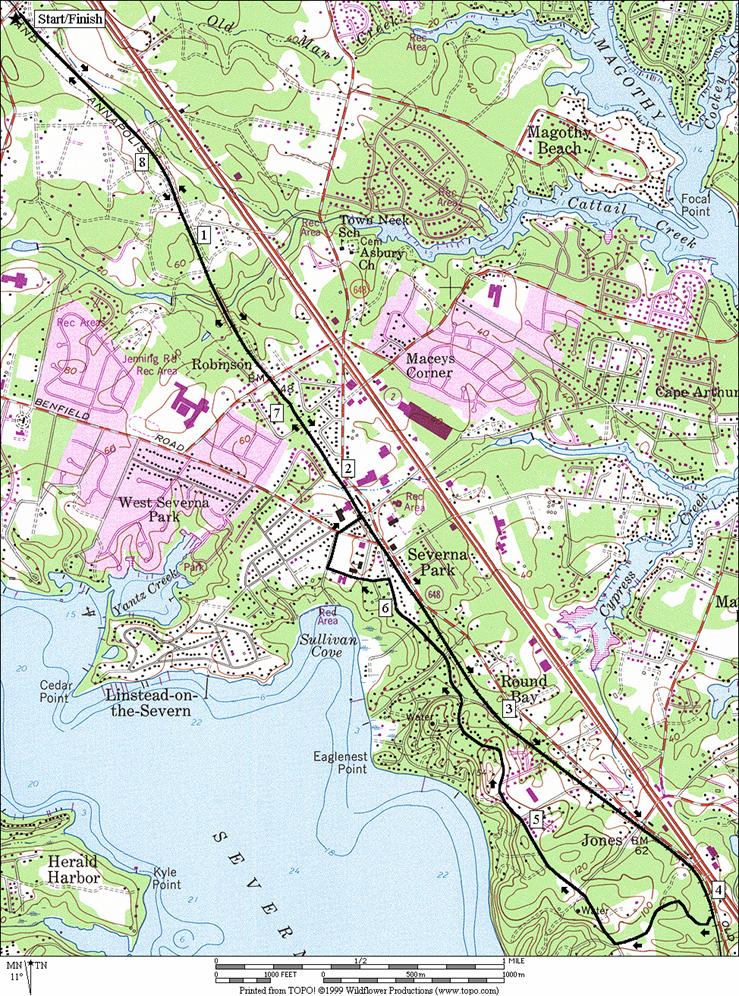
Severna
Park (8.65 miles, VII)
Going
south on the B&A Trail from Earleigh
Heights, the trail is quiet at
first. Activity picks-up at the town of Severna
Park, which is anchored on a narrows between the Severn
River and the Magothy
River. Unfortunately not many views of the river or
bay waters can be seen on route. This is
due to private properties lining the shores.
Passing Severna Park at first, a turnaround is
made at B&A Trail mile mark 3.
There, a spur trail and quiet suburban streets connect you to Old
County Rd. Old
County Rd. is a twisting but generally quiet paved
road. There are long segments with no
sidewalk and some limited-sight turns to pass through. At Severna Park again,
the route passes by the Severn Prep
school before returning to the B&A
Trail.
Nearby
and Connecting Zones
Baltimore
and Annapolis Trail - Boulter=s
Way
Baltimore
Washington International
Airport, Thomas A. Dixon Aircraft
Observation Area
What
to do Afterward
Food
and Drink
Carini=s
Pizza (and subs) - Severna Park, MD
- (410) 647‑115
Ledo Pizza - Severna Park, MD
- (410) 544‑3344
Gourmet
Connection - Severna Park, MD
- (410) 544‑3021
Entertainment
and Edification
Historic
Annapolis
Pasadena
Roller Skating Center - Pasadena, MD
- (410) 437‑3636
Glen Burnie
Distance: 14.05 miles
Rating: X; mostly flat paved railroad
grade trails; partial tree cover
L 0.0 on
the trail from the ranger station to cross Earleigh
Heights Rd
0.15 trail
X on R at Chestnut Hill and Light St
intersection (bench)
0.2 trail
X on L to Finnegan Dr
(unmarked)
0.4 trail
X on L to Copperwood Dr
(unmarked)
0.95 Mile
Mark 8
1.95 Jumper=s Hole Rd
(store)
2.05 Jumper=s Hole Rd
2.95 Mile
Mark 10
3.3 end bridge over Rte 100; Marley Station Mall
3.6 trail
X on R to mall parking
3.95 trestle
bridge, then Mile Mark 11
4.95 Mile
Mark 12
5.95 Mile
Mark 13, then Oak La NW (water)
XS 5.75 at Robert
Crain Hwy, Rte 3
L 6.3 end
of B&A trail; use Dorsey Rd
sidewalk toward BWI Trail
BL 6.4 trail
X on L toward BWI Trail leaves Dorsey Rd
6.65 trail
X on R; octagon shelter on L; Sawmill
Creek Park
(restrooms & water)
BL 6.8 trail
X after ball fields
BR 7.0 at
split in trail
L 7.05 at
T at ballfields to stay on loop
7.3 Charlie
Eckman La (Sawmill
Creek Park
entrance road)
7.35 trail
X on R between tennis courts
R 7.4 trail
X on R after tennis courts
L 7.45 at
T on BWI and B&A connector trail
BR 7.65 at Dorsey
Rd
R 7.8 B&A
Trail
8.1 Mile
Mark 13
8.15 Oak
La NW (water)
XS 8.35 at Robert
Crain Hwy, Rte 3
9.1 Mile
Mark 12
10.1 Mile
Mark 11, then trestle bridge
10.45 trail
X on L to mall parking
10.8 begin
bridge over Rte 100
11.1 Mile
Mark 10
12.05 Jumper=s Hole Rd
12.13 Jumper=s Hole Rd
(store)
13.1 Mile
Mark 8
13.7 trail
X on R to Copperwood Dr
(unmarked)
13.9 trail
X on R to Finnegan Dr
(unmarked)
13.95 trail
X on L to Chestnut Hill and Light St
intersection (bench)
14.05 ranger
station after crossing Earleigh Heights Rd
Glen
Burnie
Kinder Farm Park
Distance: 4.3 miles
Rating: III; paved trails and sidewalks; a
few modest hills
L 0.0 on
the trail from the ranger station to cross Earleigh
Heights Rd
0.15 trail
X on R at Chestnut Hill and Light St
intersection (bench)
0.2 trail
X on L to Finnegan Dr
(unmarked) (return route)
L 0.4 trail
X on L to Copperwood Dr
(unmarked)
S 0.45 at
trail end onto Copperwood Dr
CL 0.55 Longfellow Rd
BR 0.8 trail
head at the end of Longfellow Rd
0.85 trail
X on L at Jumper=s Hole
Rd; go S into Kinder
Farm Park
L 0.9 trail
X on L is the loop trail at Gali
Sanchez Way
1.15 trail
X on R to fields and parking
1.35 trail
X on L to Kinder Farm
Park parking on Earleigh
Heights Rd (unmarked)
1.4 trail
X on R to fields and parking
1.55 trail
X on L to tennis
1.85 trail
X on L to houses
1.9 trail
X on L to Rock Ridge Rd
(unmarked)
2.2 trail
X on L to houses
2.75 gravel
road
L 3.1 at
Kinder Farm Park Rd to stay
on the loop trail
3.3 trail X on R at Gali
Sanchez Way (completes loop)
CR 3.35 Jumper=s Hole Rd
L 3.45 Finnegan Dr
S 4.0 trail
head at the end of Finnegan Dr
4.1 sewage
pumping station
R 4.15 B&A
Trail
4.2 trail
X on L to Chestnut Hill and Light St
intersection (bench)
R 4.3 ranger
station after crossing Earleigh Heights Rd
Severna Park
Distance: 8.65 miles
Rating: VII; paved trails and sidewalks; a
few modest hills
R 0.0 from
the Earleigh Heights
ranger station
0.05 trail
X on R and Mile Mark 7
0.9 Whites Rd
1.05 Mile
Mark 6
1.1_
Md Brides La
1.6 Robinson Rd
1.95 trail
X on R to park/school
2.15 Riggs Rd (water)(return route)
2.25 Evergreen Rd; Olde Severna Park
2.7 wooden
bridge over Round Bay Rd
3.05 Mile
Mark 4
3.4 Hoyle Rd
3.6 Jones Station Rd
R 4.05 paved
trail X on R; Mile Mark 3
S 4.15 Donzi Ct
L 4.2 Bellview Dr
R 4.45 Old County Rd
5.05 Hoyle Rd
L 6.1 Park Place
R 6.3 Maple
Ave (Severn College
Prep school)
XS 6.45 Evergreen
Rd; Maple Ave becomes Riggs
Rd
L 6.55 B&A
Trail at Riggs Rd (water)
6.7 trail
X on L to park/school
7.1 Robinson Rd
7.55 Md Brides La
7.65 Mile
Mark 6
7.8 Whites Rd
8.6 trail
X on L and Mile Mark 7
R 8.65 Earleigh
Heights ranger station
Severna
Park