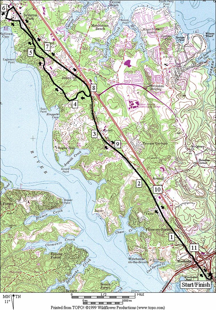
Baltimore & Annapolis Trail -Boulter=s Way
The
southern terminus of the Baltimore
and Annapolis (B&A) Trail is
right off Rte. 450, not far from Annapolis. Awkwardly, the trail is on roads at
first. The shoulder of Rte. 450 and the
shoulder of Boulter=s
Way must be used for the first six-tenths of a mile. After that, the paved trail is trail
lovely. The almost rural setting is
lined with evergreens. The trail curves,
rises, and falls more than other parts of it nearer Glen Burnie. In-line skaters achieve high speeds on the
grades. Going in the other direction, Annapolis
can be accessed by taking Rte. 450 over the Old
Servern River
Bridge, for only 1.6 miles, however
there is no separate trail.
Getting
There
From
the Capital Beltway (I-495), take John Hanson Hwy.,
Rte. 50 north toward Annapolis. After passing Annapolis approximately 20
miles from the beltway, cross the Severn River, and exit immediately to the
right onto Rte. 450. Almost as soon as
you get onto Rte. 450, turn right into the parking lot.
Area
Routes
Old
County Road (11.65 miles, X)
This
route is a variation of the Severna Park route that
starts in Earleigh Heights. Instead of coming from the north, the
approach to the loop is from the south.
The hilliest parts are in the beginning but all of the
route on the trail is well graded.
In-line skaters are frequently found on the B&A Trail probably
because much of it is uninterrupted by roads.
The loop portion begins by leaving the B&A trail at mile mark
3. Crossing through suburban
neighborhoods, Old County Rd.
is quickly reached. Old
County Rd. is relatively quiet however some
caution is needed at blind curves. There
are some short steeper hills on Old County Rd.
too. Looping past a prep school in
Severna Park, the route returns to the B&A Trail which you take all the way
back to Boulter=s
Way.
Nearby
and Connecting Zones
Baltimore
and Annapolis Trail - Earleigh Heights
Quiet
Waters Park,
Annapolis
What
to do Afterward
Food
and Drink
Main
Street Seafood & Grill - Annapolis,
MD - (410) 626‑1170
Griffins
Restaurant - Annapolis, MD
- (410) 268‑2576
Entertainment
and Edification
R 0.0 from
the parking lot gate, turn R on Rte 450 using the shoulder (!)
R 0.05 Boulter=s
Way
BR 0.65 trail
X on R is the B&A Trail
1.15 Mile
Mark 0.5
1.6 Severn Way
1.65 water
2.15 Mile
Mark 1.5
2.5 Glen
Oban Dr
2.65 Mile
Mark 1.5
2.95 Asquith
La
3.0 wooden
bridge
3.1 Old
County Rd
L 3.65 trail
X on L at Mile Mark 3
3.75 Donzi Ct
L 3.8 Bellview Dr
R 4.05 Old County Rd
L 5.7 Park Place
R 5.9 Maple Ave
(Severn College Prep school)
XS 6.05 Evergreen
Rd; Maple Ave becomes Riggs
Rd
R 6.15 B&A
Trail at Riggs Rd (water)
6.25 Evergreen Rd; Olde Severna Park
6.7 wooden
bridge over Round Bay Rd
7.05 Mile
Mark 4
7.4 Hoyle Rd
7.6 Jones Station Rd
8.05 paved
trail X on R; Mile Mark 3
8.6 Old
County Rd
8.65 wooden
bridge
8.75 Asquith
La
9.05 Mile
Mark 2
9.2 Glen
Oban Dr
10.0 water
10.1 Severn Way
L 11.05 Boulter=s
Way
L 11.65 Rte
450 (!); use shoulder
L 11.65 to
parking lot gate